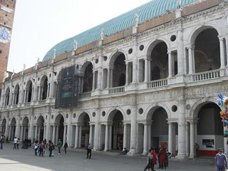
Stage Two Vicenza – Marano Vicentino (Km 26)

Route information
Starting point
Vicenza, Piazza dei Signori, Basilica Palladiana
Parking
All car parks and parking spaces maintained by A.I.M. Mobilità
Motorway
E70, A4 MI-VE, A31 Valdastico
Main roads
SS 53 Postumia- SR 11 from Padova-Verona
SP 247 Riviera Berica
SS 46 from Schio-Thiene
SP 248 from Marostica-Bassano
SP 247 Riviera Berica
SS 46 from Schio-Thiene
SP 248 from Marostica-Bassano
Museums and monuments
For information visit www.comunevicenza.it Vicenza da vivere
When
All year round (along the paths between Leogra-Timonchio pay special attention during hunting season as there may be hunting hides in the vicinity)
Technical details
Easy, completely flat.
Terrain
Asphalt, from the start around the area of Dal Molin in the northern suburbs and from the end of the woods in Dueville as far as the beginning of the Timonchio in Villaverla
Dirt tracks, north of via Polesella-Bosco Dueville
Unpaved-grass tracks along the embankment of the Bacchiglione from Vicenza to Vivaro and the embankment along the Timonchio from Villaverla to Marano.
Dirt tracks, north of via Polesella-Bosco Dueville
Unpaved-grass tracks along the embankment of the Bacchiglione from Vicenza to Vivaro and the embankment along the Timonchio from Villaverla to Marano.
Time
- pace 4 kmph > 6 hours 30 minutes
- pace 6 kmph > 4 hours 20 minutes
- pace 8 kmph > 3 hours 10 minutes
- pace 18 kmph > 1 hour 30 minutes by bike
Road crossings
- Corso Palladio pedestrianised area
- Viale d’Alviano traffic lights at the crossing
- Viale dal Verme traffic lights at the crossing
- All road section leaving Vicenza which are not on cycle paths
- Polegge road
- The bridge in Cresole
- The bridge in Vivaro
- Section along Via Timonchio in Caldogno
- SP 50, Novoledo
- Villaverla, near Telwin, 3 crossings at roundabouts
- The bridge at Borgo Redentore (the “Vacheta” road) in Villaverla
- The bridge on the Molina-Malo road
- Marano by-pass Via Timonchio
Route map
Elevation profile


